What can we help you with?
Below you’ll find answers to the most common questions you may have. Also, please feel free to check out our Application Toolkits for Maritime Area Consents and Maritime Usage Licences which have additional guidance and information. If you still can’t find the answer you’re looking for, just Contact us!
Our questions are categorised into the following areas:
General
1. What is MARA?
The Maritime Area Regulatory Agency (MARA) is a statutory body and regulator under the aegis of the Department of Climate, Energy and the Environment with headquarters located in Wexford. It was established by Part 3 of the Maritime Area Planning Act 2021 (MAP Act) and subject to the provisions of the MAP Act, is independent in the performance of its functions.
2. What are MARA’s functions?
MARA has a key role to play in the new streamlined consenting and compliance system for the maritime area (as defined in the Act) and its functions are set out in section 43 of the MAP Act
3. What is MARA’s remit?
MARA’s remit extends from the high water of ordinary or medium tides to the outer limit of the continental shelf and includes the sea and tidal areas of internal waters. Section 3 of the MAP Act sets out the application of the Act.
Údaruithe
4. What authorisations are regulated by MARA?
- Maritime Area Consents (MACs).
- Maritime Usage Licences (MULs).
- Foreshore Authorisations under the Foreshore Act, 1933.
- Conditions of planning granted by An Coimisiún Pleanála in the maritime area.
5. What is the foreshore?
The foreshore of Ireland is the land and seabed between the high water of ordinary or medium tides (shown HWM on Ordnance Survey maps) and the twelve- mile limit (12 nautical miles equals approximately 22.24 kilometres). Foreshore also covers tidal areas of rivers, particularly estuaries.
6. How do I get information about an existing foreshore lease or licence?
Visit MARA’s website and see existing authorisations.
Ceantar Muirí na hÉireann
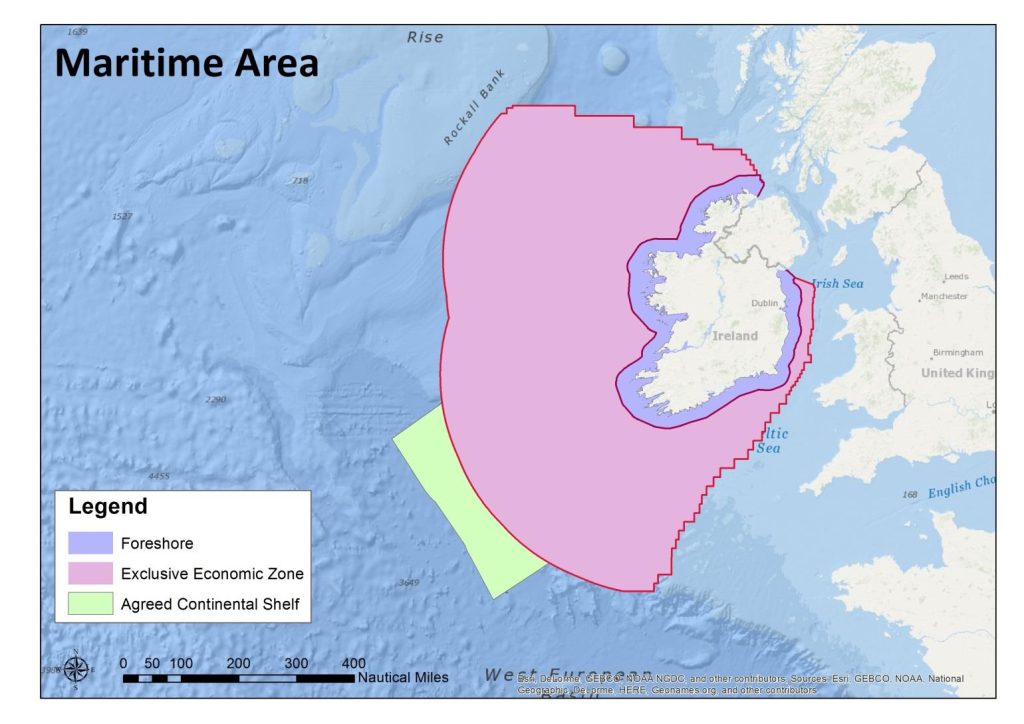
7. What is the Exclusive Economic Zone (EEZ)?
The Irish EEZ (or Exclusive Economic Zone) extends from the 12 nautical mile (approx. 22.24kms) limit to approximately 200 nautical miles (370kms) off the coast of Ireland in places, as shown in pink in this map of Irelands Maritime Area. Ireland has jurisdiction over both living and non-living resources within its EEZ.
Maritime Usage Licence
8. When do I need a Maritime Usage Licence (MUL)?
Schedule 7 of the MAP Act sets out the maritime usages for which a MUL is required.
9. What is maritime usage?
Maritime usage is defined in section 2 of the MAP Act as:
“maritime usage”, in relation to the maritime area, means any activity, operation, works or development undertaken in that area for any purpose (including conservation), and includes—
(a) the construction or use, or both, of any infrastructure in that area associated with, or otherwise supporting, the activity, operation, works or development, and
(b) the maintenance of such infrastructure,
and references in this Act to “proposed maritime usage” shall be construed accordingly;
10. Has any further clarity been provided around maritime usage?
It has been clarified in Circular MP01/2025 by the Department of Climate, Energy and the Environment that an activity which is non-commercial and constitutes an individual or group of individuals’ ordinary reasonable enjoyment of the maritime area, or an activity that is of a passive observational nature, is not contemplated to be included in the application of the definition of maritime usage.
Compliance & Enforcement
11. Can I make a complaint to MARA about activity that should have an authorisation or may be in breach of an authorisation?
Yes. First check it is in MARA’s remit to address. Where there is a breach of condition or unauthorised activity, complete the online Complaints Form. Where possible include evidence of the alleged activity. Full details here.
12. What happens after I submit a complaint referenced at Q.11 above?
- MARA acknowledges complaints within working 5 working days.
- MARA assesses if the complaint falls within its remit and will contact you if more information is required.
- Where the complaint is not within MARA’s remit, it is redirected to the relevant authority and MARA will inform you of the referral.